
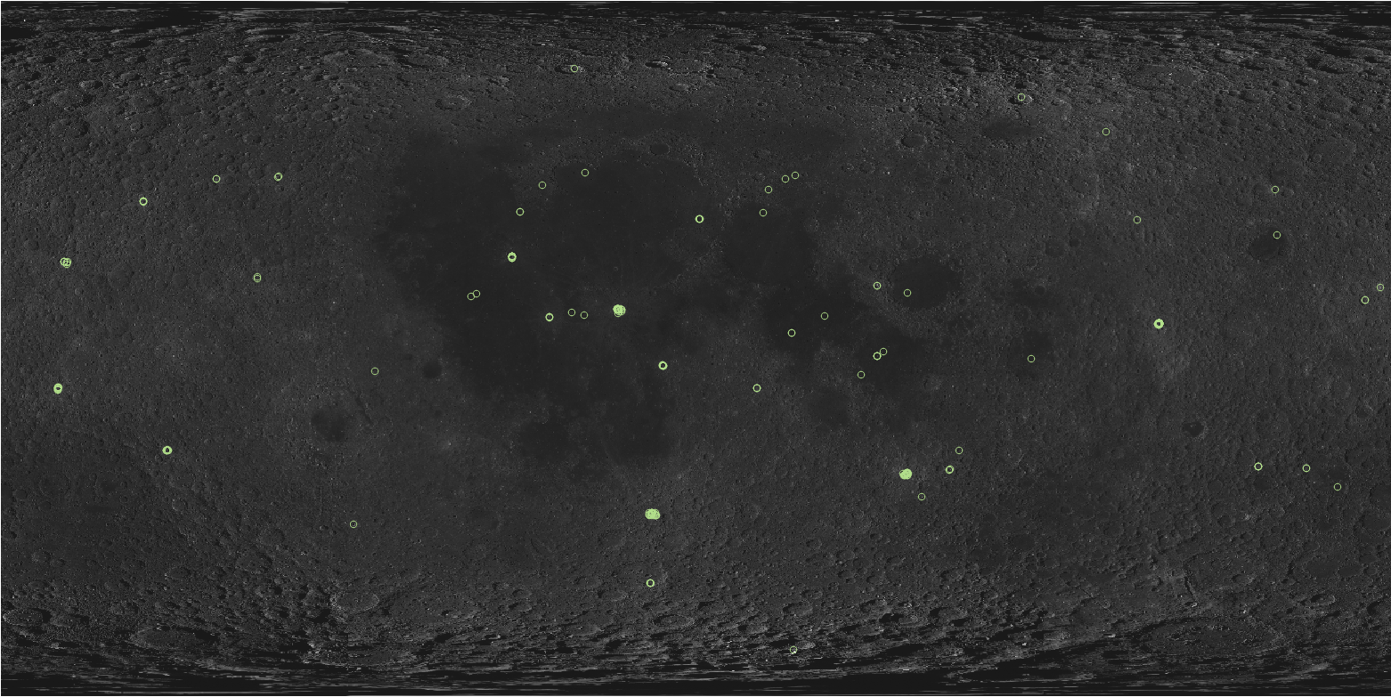
Shapefile of lunar pit locations in IAU MOON2000 geographic reference system. Lunar pits are small collapse features (10s to 100s of meter scale) characterized by vertical walls. For each pit, we have recorded the location, dimensions, and various feature descriptors (such as whether the pit is within a positive or negative relief feature, or has a path to the floor uninterrupted by a vertical wall), as well as a detailed description of the pit and environs. Where possible, depths are calculated from shadow measurements on three minimally-slewed images. Each pit is named based on the host feature's name, usually followed by a number roughly corresponding to order of discovery and a letter if the pit is part of a multi-pit cluster (e.g. "King 1a" and "King 1b"). Latitude and longitude coordinates were computed from an average of multiple images and so should be more accurate than the ~31 m uncertainty of an arbitrary NAC image. However, we also report the line/sample location of the center of each pit in one LROC NAC frame to ensure unambiguous identification of each pit regardless of any future updates to the LROC ephemeris or changes to the lunar reference frame.
When citing this product, use the following reference:
Wagner, R. V. and Robinson, M. S. (2021). Occurrence and Origin of Lunar Pits: Observations from a New Catalog. 52nd Lunar and Planetary Science Conference, Abstract #2530. https://www.hou.usra.edu/meetings/lpsc/2021/pdf/2530.pdf
| Longitude Domain | Product Name |
|---|---|
| 180 | LUNAR_PIT_LOCATIONS_180 |
| 360 | LUNAR_PIT_LOCATIONS_360 |
Column Descriptions:
Name: Unique identifier for the pit. Usually consists of "<Crater Name><Number><Optional Letter>", where:
- <Crater Name> is the name of the host crater
- <Number> is an arbitrary number, roughly corresponding to discovery order, but not neccesarily sequential.
- <Optional Letter> is a further identifier for pits within clusters (groups of multiple pits within ~100 meters of one another), usually ordered from largest to smallest or along a line. In cases where a pit has a deeper pit in its floor, those pits are listed separately, lettered from outermost to innermost.
Terrain: Host terrain of the pit. Mare, Highland, or Impact melt.
Type: Sub-categorization of pit.
- Fracture: This pit is a wide section of a longer fracture.
- Large Bowl: This pit is a wide bowl-shaped collapse feature, with most of the depth coming from the floor, rather than walls, but does have a vertical wall that completely or almost completely encircles the pit.
- Uncertain: It is not clear whether or not this feature qualifies as a "pit".
HostFeatur: Host feature: Name of the feature the pit is in (e.g. "Copernicus" or "Mare Tranquillitatis").
Latitude: Latitude coordinate in degrees of the approximate center of the pit.
Longitude: Longitude coordinate in degrees of the approximate center of the pit. Coordinates are estimated from multiple NAC images, and are usually accurate to within 30 m (see Wagner et al. 2017, https://doi.org/10.1016/j.icarus.2016.05.011/ ).
FunMaxDiam: Funnel Max Diameter (m). Diameter measured across the greatest extent of the funnel/depression surrounding the pit, determined from a low-Sun image. Funnel diameters are a rough measure out to where there is some photometric darkening/brightening of the terrain due to slope change, and should be assumed to have an uncertainty of ~5 meters, erring on the side of reporting too small a value.
FunMinDiam: Funnel Min Diameter (m). Diameter perpendicular to the Funnel Max Diameter.
InMaxDiam: Inner Max. Diameter (m). Length of the maximum dimension of the vertical-walled inner pit. May be "N/A" if there are not vertical walls bounding both ends of the long axis ofthe pit (e.g. a wall collapse, as in the Lacus Mortis Pit). For rectilinear pits, this is usually parallel to the longest walls, rather than the true longest diagonal dimension.
InMinDiam: Inner Min Diam (m). Maximum vertical-wall-to-vertical-wall distance perpendicular to the long axis of the pit. May be N/A if there are not vertical walls on both sides.
Azimuth: Orientation of the long axis of the inner pit (where applicable) in degrees clockwise from north, rounded to the nearest 5 degrees. All azimuths are >0; 0 is reserved as a special value for pits with no long axis.
Depth: Average of depth measurements in meters from up to three individual images (see below). In cases where only minimum depth measurements exist, depth is based on the highest-Sun image(s).
Depth_Num: Numeric only version of the Depth field (see above).
Depth1/Depth2/Depth3: Fields for depth measurement in meters from shadow measurements on individual NAC images.
- Depth1 is usually from the image with the shadow boundary closest to the middle or apparent lowest point of the pit.
- In general, measurements are from the top of a vertical wall to the floor, but some measurements may include some funnel, and impact melt pits rarely have uniform rim heights.
- Where possible, depth measurements from at least two walls are included.
- If possible, only images with emission angles <3 degrees were used to measure depths.
- If a depth measurement is "greater than X", then no floor was visible, and "X" is the lowest point that sunlight could have reached within the pit in that image. Parts of the floor could lie above this depth if they were on the sunward side of the pit in that image.
- See Warnings entry for specific possible complications in the depth measurements of a pit.
Image1/Image2/Image3:
Fields for Image IDs of the images used to get Depth1/Depth2/Depth3.Image1Line: Line in unprojected NAC image (Image1) as a projection-independent reference for exactly what feature this pit is.
Image1Samp: Sample in unprojected NAC image (Image1) as a projection-independent reference for exactly what feature this pit is.
Inc1/Inc2/Inc3: Fields for the incidence angles of Image1/Image2/Image3, signed such that images with negative numbers have the Sun in the West, and those with positive numbers have the Sun in the East.
Em1/Em2/Em3: Fields for emission angles of Image1/Image2/Image3, signed such that images with negative numbers have the spacecraft in the West, and those with positive numbers have the spacecraft in the East.
Time1/Time2/Time3: Fields for local solar time-of-day of the image.
- 6.00 is dawn, 12.00 is noon, 18.00 is dusk. This is not an <hour>.<minutes> format: the decimal fraction goes from 00 to 99.
Res1/Res2/Res3: Fields for resolution of Image1/Image2/Image3 in meters/pixel.
StereoIDs: Image IDs of the the best stereo pair of the pit, if any exist.
DTMs: PDS identifier of the best NAC DTM that includes the pit, if any exist.
OtherImgs: Other Useful Images; Images that may be helpful for interpreting the shape of the pit, other than the depth measurement images and any stereo pair.
Warnings: Specific warnings about things that may affect the interpretation of the recorded data (unusual wall or floor topography, high uncertainty in shadow lengths, etc.).
Description: (CSV ONLY; frequently exceeds the ESRI shapefile limit of 256 characters) Verbose description of the pit shape and surrounding terrain features.
- For pits in a cluster (e.g. 1a, 1b, 1c), the descriptions assume that you are reading all of them in order. Most regional description will be in the description for pit "a".
- Common abbreviations: North (N), South (S), East (E), West (W), Positive Relief Feature (PRF).
The following fields are Yes/No flags of whether the pit has a given feature.
- Possible values are yes (Y), no (N), likely yes (Y?), likely no (N?), or unknown (?).
- Note that for mare and highland pits, the radius for "nearby" is increased to ~2 km from the impact melt pit standard radius of ~300 m.
EntryRamp: Whether the pit appears to have an unbroken slope from surrounding surface to floor. Note that this ramp may not actually be traversable in practice, due to slope or rockiness.
Overhang: Whether there is a confirmed overhang of any depth on any side, based on off-nadir imaging. Usually unknown.
NearPits: Nearby Pit(s); Whether there is any other vertical-walled collapse feature (including other pits of the same cluster) within ~300 m.
NearFract: Nearby Fracture(s); Whether there are any fractures within ~300 m.
NearDepr: Nearby Depression(s); Whether there are any negative relief features other than apparent impact craters, pits, or fractures within ~300 m.
InDome: Whether the pit is on some sort of local positive relief feature.
BesideDome: Beside Dome; Whether the pit is on flat ground within ~1 diameter of the base of some sort of local positive relief feature.
InDepr: In depression; Whether the pit is in some sort of negative relief feature that appears unrelated to the funnel.
ColinePit: Colinear pits; Whether there are at least two other pits that form an approximate line with this one.
ColineDepr: Colinear depression(s); Whether this pit is roughly in line with any nearby non-fracture elongate negative relief feature. If the pit is in a depression, disregards continuously-connected parts of that depression.
ColinFract: Colinear fracture(s); Whether this pit is roughly in line with a nearby fracture.
Shapefile updated on 3/9/2021
Lunar Pit Locations Shapefile
Extra Downloads
- Zip file containing shapefile for Lunar Pit Locations - 180 domain - (1.19 MB)
- Zip file containing shapefile for Lunar Pit Locations - 360 domain - (1.19 MB)
- Raw csv data for Lunar Pit Locations - (163.50 KB)
- PDS Directory For Lunar Pit Locations - 180 domain
- README Lunar Pit Locations - (9.75 KB)
- PDS Directory For Lunar Pit Locations - 360 domain

