
The two Narrow Angle Cameras (NACs) provide high-resolution (0.5 to 2.0 m/pixel) panchromatic images over a combined 5 km swath. NAC images acquired on consecutive orbits, or occasionally over non-consecutive orbits under very similar lighting conditions (e.g. less than 5° difference in incidence angle and the same sun direction), can be combined to create controlled mosaics. A control network is generated to tie the images to the most accurate ground truth available and a bundle adjustment is performed to correct for pointing errors and image alignment. The images are then map-projected and mosaicked together into an almost seamless mosaic of the region. The digital terrain model used for the radius source and for map-projection are listed below.
There are a few files included to assist in evaluating the controlled mosaic. These include:
Bundleout.txt - The output text file from the ISIS3 jigsaw tool summarizing the results of bundle-adjusting the control network. For more information, see: https://isis.astrogeology.usgs.gov/Application/presentation/Tabbed/jigsaw/jigsaw.html
Residual Plot - A plot of every residual overplotted onto a 20 m/px version of the mosaic. This is useful for local inspection of residuals (in pixels), which ideally should be zero, but we consider residuals less than one acceptable.
Binned Residual Plot - A plot with the residuals (in pixels) binned by 0.05 degrees of latitude and longitude. It can be used to determine if there are any trends in the residuals over the entire mosaic. Ideally residuals should be very close to zero and there should be no trends in the directions.
In addition to the provided files, we have included the Sigma0 value below, which is the standard deviation of unit weight and a summary number for the bundle-adjustment performed by jigsaw. Ideally, Sigma0 should be less than one.
When citing this product, use the following reference:
Klem, S. M., Henriksen, M. R., Stopar, J., Boyd, A., & Robinson, M. S. (2014). Controlled LROC Narrow Angle Camera High Resolution Mosaics. In Lunar and Planetary Science Conference (Vol. 45, abstract #2885). https://www.hou.usra.edu/meetings/lpsc2014/pdf/2885.pdf
For more information about this and other RDRs, see the RDR Software Interface Specification (SIS) at http://lroc.sese.asu.edu/data/LRO-L-LROC-5-RDR-V1.0/LROLRC_2001/DOCUMENT/RDRSIS.PDF.
PDS PRODUCT NAMING CONVENTION
The PRODUCT_ID naming convention for LROC NAC ROIs is:
NAC_ROI_xxxxxxxxSSv_AyyyBzzzz[_##M].IMG where
- NAC_ROI = indicating it's a NAC ROI product
- xxxxxxx = words specifying the sitename (8 characters)
- SS = LO for low Sun angle or HI for high Sun angle
- v = incremental character for distinguishing multiple mosaics with similar lighting of the same region. Letters are used for individual mosaics and numbers are used for composite mosaics composed of mulitiple controlled mosaics.
- A = projection type (E for equirectangular, P for polar stereographic)
- yyy = center latitude to the nearest 10th of a degree
- B = N for northern hemisphere, S for southern hemisphere
- zzzz = center longitude to the nearest tenth of a degree. The longitude domain for all NAC DTMs is 360 positive east.
- [_##M] = indicates the pixel scale in meters; used only for supplementary lower resolution products.
Example: NAC_ROI_APOLLO15LOC_E252N0018.IMG is a NAC ROI of the Apollo 15 landing site with low-Sun. C indicates it's the third low-Sun mosaic of the Apollo 15 landing site produced. This mosaic is centered at latitude=25.2N, longitude=1.8E and is in equirectangular projection.
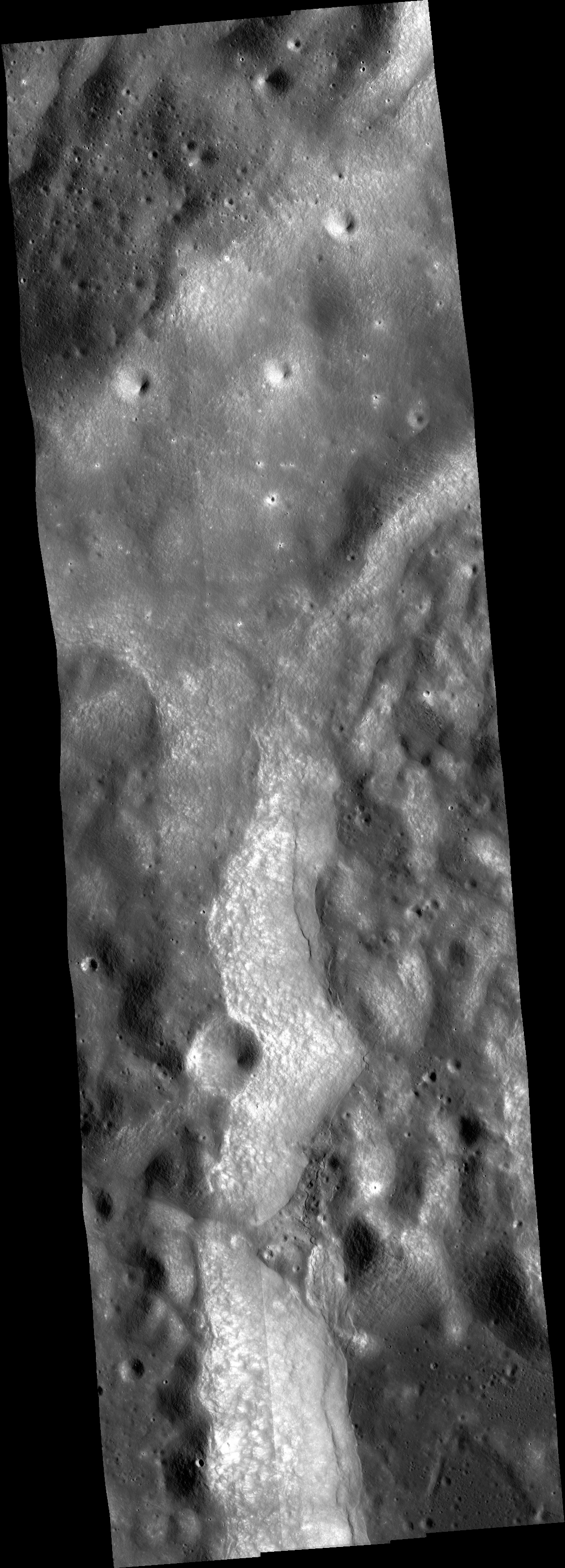
| RDR Name | NAC_ROI_TSIOLKOVLOI_E197S1261 |
| Site Name | West Rim of Tsiolkovskiy |
| Center Lat | -19.7 |
| Center Lon | 126.1 |
| Pixel Scale | 1.00 m/px |
| Image Start Time (UTC) | 2020-07-19 11:50:54.193+00 |
| Image Stop Time (UTC) | 2020-07-19 13:48:38.736+00 |
| # Images | 4 |
| Incidence | Low Sun |
| Minimum Latitude | -20.51 |
| Maximum Latitude | -18.82 |
| Minimum Longitude | 125.73 |
| Maximum Longitude | 126.38 |
| Sigma0 | 0.56 |
| Map Projection DTM | SLDEM2015 [BARKERETAL2016] |
| Radius Source | SLDEM2015 [BARKERETAL2016] |
Images used, in order of layering from front to back:
| Image ID | Center Lat | Center Lon | Incidence | Pixel Scale |
| M1349798721L | -19.67 | 126.04 | 66° | 0.97 m/px |
| M1349798721R | -19.69 | 125.88 | 66° | 0.97 m/px |
| M1349805754R | -19.66 | 126.07 | 65° | 0.93 m/px |
| M1349805754L | -19.65 | 126.22 | 65° | 0.94 m/px |
To eliminate brightness differences across the mosaic, a manual histogram equalization was performed by multiplying the images by the ratios of I/F values in overlapping regions. The I/F values to perform these caculations were recorded using the qview histogram tool from USGS ISIS.
| Image ID | Multipliers |
| M1349798721L | 1.01 |
| M1349798721R | 1.04 |
| M1349805754L | 1.03 |
| M1349805754R | 1.00 |
Link to browse PNG
http://lroc.sese.asu.edu/data/LRO-L-LROC-5-RDR-V1.0/LROLRC_2001/EXTRAS/BROWSE/NAC_ROI/TSIOLKOVLOI/NAC_ROI_TSIOLKOVLOI_E197S1261.BROWSE.PNG
West Rim of Tsiolkovskiy low-Sun controlled NAC mosaic (I)
Mosaic (1.00 m/px) (click for more information)
Extra Downloads
Lower Resolutions
Supplemental Downloads

