
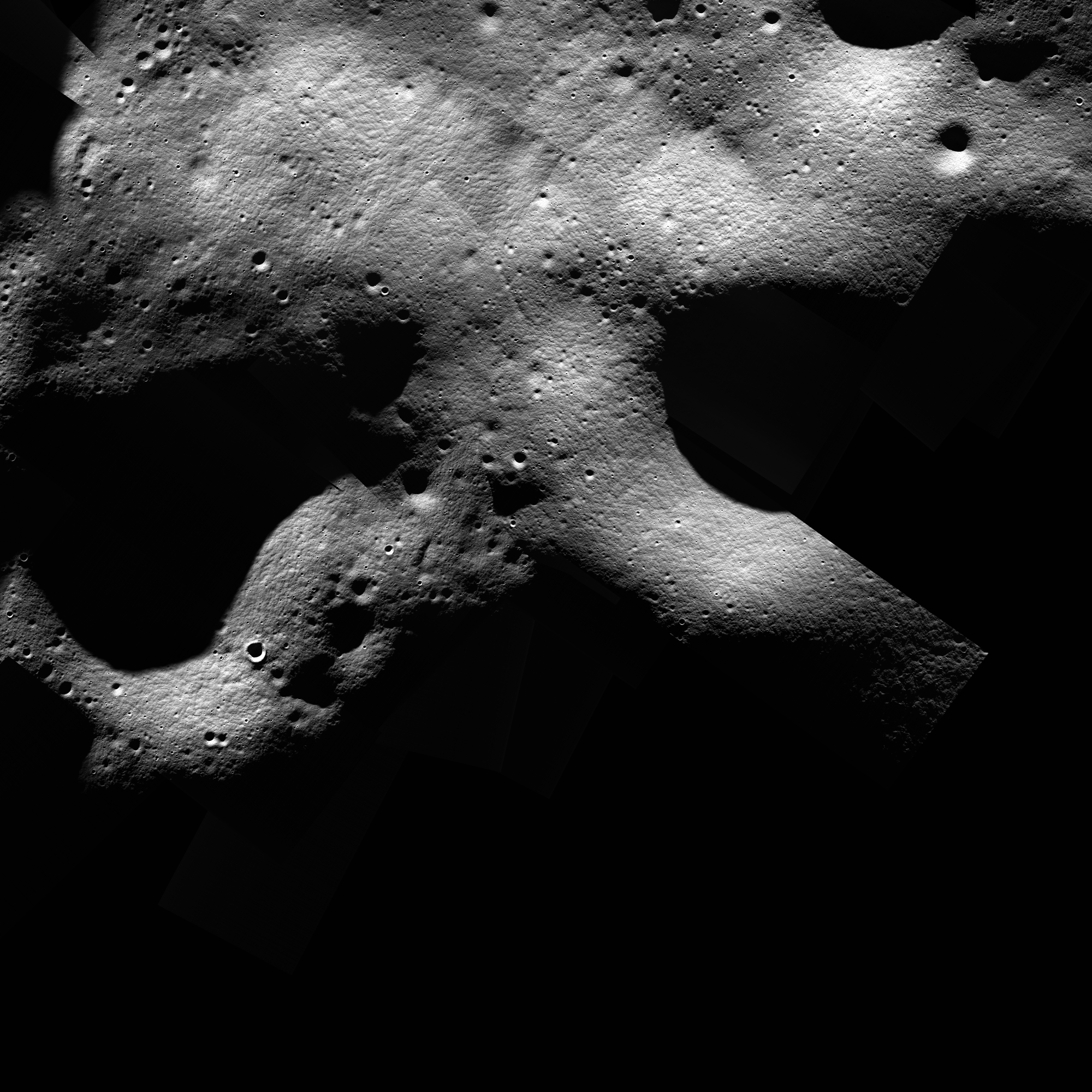
This sub-solar longitude mosaic is composed of images with consistent lighting geometries (sub-solar longitudes from 315 to 15) selected to optimize illuminated terrain coverage over an Artemis III candidate landing site. For a first pass at offset correction, we used the results of aligning most of the LROC NAC images poleward of 84°S as described in Wagner et al. 2022 (LPSC LIII, Abstract no. 2573). For our second pass at offset correction, we compared the mosaic to the LOLA shaded relief product (5 m pixel scale). We estimate the absolute positional accuracy to be 5 to 20 m. [NASA/GSFC/Arizona State University]
When citing this product, use the following reference: Henriksen, M. R., Burnette, S.R., Brown, H.M., Wagner, R.V., Robinson, M.S., Collins, W.M., Grieser, S.A., Boyd, A.K. (2023), Optimized Illuminated Terrain Coverage of the Candidate Artemis III Landing Sites with LROC NAC Controlled Mosaics. European Lunar Symposium, https://sservi.directus.app/assets/2483b7e0-a336-443d-8739-3d5f4756e1fb.pdf, pg 134-135.
For more information about this and other RDRs, see the RDR Software Interface Specification (SIS) at http://lroc.sese.asu.edu/data/LRO-L-LROC-5-RDR-V1.0/LROLRC_2001/DOCUMENT/RDRSIS.PDF.
PDS PRODUCT NAMING CONVENTION
The PRODUCT_ID naming convention for LROC NAC ROIs is:
NAC_ROI_xxxxxxxxSSv_AyyyBzzzz[_##M].IMG where
- NAC_ROI = indicating it's a NAC ROI product
- xxxxxxx = words specifying the sitename (8 characters)
- SS = LO for low Sun angle or HI for high Sun angle
- v = incremental character for distinguishing multiple mosaics with similar lighting of the same region. Letters are used for individual mosaics and numbers are used for composite mosaics composed of mulitiple controlled mosaics.
- A = projection type (E for equirectangular, P for polar stereographic)
- yyy = center latitude to the nearest 10th of a degree
- B = N for northern hemisphere, S for southern hemisphere
- zzzz = center longitude to the nearest tenth of a degree. The longitude domain for all NAC DTMs is 360 positive east.
- [_##M] = indicates the pixel scale in meters; used only for supplementary lower resolution products.
Example: NAC_ROI_APOLLO15LOC_E252N0018.IMG is a NAC ROI of the Apollo 15 landing site with low-Sun. C indicates it's the third low-Sun mosaic of the Apollo 15 landing site produced. This mosaic is centered at latitude=25.2N, longitude=1.8E and is in equirectangular projection.
| RDR Name | NAC_ROI_SHKLTNPKLOD_P888S1247 | |||
| Site Name | Peak near Shackleton 315 to 15 degree sub-solar longitude | |||
| Center Lat | -88.8 | |||
| Center Lon | 124.7 | |||
| Pixel Scale | 1.00 m/px | |||
| Image Start Time (UTC) | 2009-11-04 02:21:19.115+00 | |||
| Image Stop Time (UTC) | 2012-09-02 05:52:39.69+00 | |||
| # Images | 44 | |||
| # Segments | 78 | |||
| Incidence | Low Sun | |||
| Minimum Latitude | -89.17 | |||
| Maximum Latitude | -88.44 | |||
| Minimum Longitude | 107.53 | |||
| Maximum Longitude | 141.84 | |||
| Min Subsolar Longitude | 315 | |||
| Max Subsolar Longitude | 15 |
| Image ID | Center Lat | Center Lon | Incidence | Pixel Scale |
| M1096274327L | -88.37 | 161.24 | 90° | 1.30 m/px |
| M1096288613L | -88.54 | 154.46 | 90° | 1.30 m/px |
| M1096288613R | -88.48 | 152.89 | 90° | 1.30 m/px |
| M1096302900L | -88.64 | 149.99 | 90° | 1.30 m/px |
| M1096302900R | -88.58 | 148.42 | 90° | 1.29 m/px |
| M1096317187L | -88.71 | 146.39 | 90° | 1.29 m/px |
| M1096317187R | -88.65 | 144.83 | 90° | 1.29 m/px |
| M1098767992R | -88.83 | 125.03 | 90° | 0.96 m/px |
| M1098782272R | -88.80 | 123.59 | 90° | 1.00 m/px |
| M1101204403R | -88.74 | 103.10 | 89° | 1.21 m/px |
| M111940545L | -89.96 | 315.65 | 88° | 1.57 m/px |
| M111940545R | -89.92 | 242.48 | 89° | 1.57 m/px |
| M111960916R | -89.93 | 108.13 | 89° | 1.60 m/px |
| M114289664L | -89.59 | 305.20 | 89° | 1.58 m/px |
| M114310019L | -89.51 | 316.05 | 89° | 1.58 m/px |
| M114310019R | -89.52 | 306.66 | 89° | 1.58 m/px |
| M114330377L | -89.53 | 325.96 | 89° | 1.59 m/px |
| M114330377R | -89.55 | 316.56 | 89° | 1.58 m/px |
| M114350734R | -89.52 | 324.06 | 89° | 1.59 m/px |
| M132334060L | -89.15 | 149.26 | 91° | 1.18 m/px |
| M132347632L | -89.20 | 146.75 | 91° | 1.18 m/px |
| M142559106L | -88.83 | 124.89 | 90° | 0.95 m/px |
| M142559106R | -88.84 | 128.41 | 90° | 0.95 m/px |
| M142572660L | -89.35 | 107.87 | 89° | 0.97 m/px |
| M142572660R | -89.37 | 114.07 | 89° | 0.97 m/px |
| M142593035R | -87.87 | 121.37 | 90° | 1.00 m/px |
| M144892907R | -89.53 | 124.18 | 89° | 0.92 m/px |
| M144899716L | -88.19 | 131.42 | 90° | 0.94 m/px |
| M144926843L | -88.72 | 119.50 | 90° | 0.98 m/px |
| M165539130L | -87.91 | 78.63 | 89° | 1.94 m/px |
| M165545917L | -87.92 | 76.82 | 89° | 1.94 m/px |
| M165552703L | -87.93 | 74.74 | 89° | 1.94 m/px |
| M165552703R | -87.88 | 76.91 | 90° | 1.93 m/px |
| M165559490R | -87.90 | 74.91 | 89° | 1.94 m/px |
| M165566276L | -87.95 | 70.52 | 89° | 1.94 m/px |
| M165573062R | -87.92 | 70.72 | 89° | 1.94 m/px |
| M167914376L | -88.11 | 78.23 | 88° | 1.41 m/px |
| M167927946R | -88.07 | 76.19 | 88° | 1.42 m/px |
| M167934730L | -88.14 | 71.62 | 88° | 1.42 m/px |
| M170635469R | -89.41 | 68.07 | 88° | 1.31 m/px |
| M170703337R | -89.50 | 70.32 | 89° | 1.26 m/px |
| M170716909R | -89.51 | 67.44 | 89° | 1.26 m/px |
| M170757625R | -89.47 | 60.68 | 89° | 1.25 m/px |
| M170764412L | -89.53 | 61.57 | 89° | 1.25 m/px |
Link to browse PNG
http://lroc.sese.asu.edu/data/LRO-L-LROC-5-RDR-V1.0/LROLRC_2001/EXTRAS/BROWSE/NAC_ROI/SHKLTNPKLOD/NAC_ROI_SHKLTNPKLOD_P888S1247.BROWSE.PNG
Peak near Shackleton 315 to 15 degree sub-solar longitude low-Sun controlled NAC mosaic (D)
Mosaic (1.00 m/px) (click for more information)
Lower Resolutions
Supplemental Downloads
Component Of

