
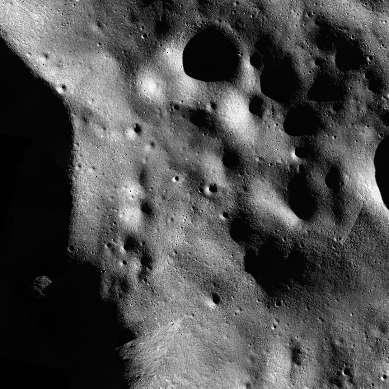
This preliminary mosaic of an Artemis III candidate landing site is composed of images selected to optimize illuminated terrain coverage. As a first step, the thousands of NAC images of the south pole were filtered to the region of interest and divided into square segments along the image track at 20 m/pixel to minimize file sizes and provide flexibility to use only illuminated portions of each image for mosaicking. To determine optimal image ordering, we used sub-solar longitudes to guide the image selection to ensure local areas had consistent lighting geometries. For a first pass at offset correction, we used the results of aligning most of the LROC NAC images poleward of 84° south as described in Wagner et al. 2022 (LPSC LIII, Abstract no. 2573). Each image segment was then map-projected at native image resolution (1 m/px) and images with sub-solar longitudes within 10° bins were mosaicked together. As a second pass at offset correction, we compared the sub-solar longitude mosaics to the LOLA shaded relief product (5 m pixel scale). The final mosaic is a 1 m/pixel 16-bit (unsigned word) GeoTiff masked along boundaries between images with different lighting and blended for a more “seamless” mosaic. This mosaic is composed of 103 NACs (235 image segments) and eight bins of 10°-20° of sub-solar longitude. We estimate the absolute positional accuracy to be 5 to 20 m.
When citing this product, use the following reference: Henriksen, M. R., Burnette, S.R., Brown, H.M., Wagner, R.V., Robinson, M.S., Collins, W.M., Grieser, S.A., Boyd, A.K. (2023) European Lunar Symposium, in press.
For more information about this and other RDRs, see the RDR Software Interface Specification (SIS) at http://lroc.sese.asu.edu/data/LRO-L-LROC-5-RDR-V1.0/LROLRC_2001/DOCUMENT/RDRSIS.PDF.
PDS PRODUCT NAMING CONVENTION
The PRODUCT_ID naming convention for LROC NAC ROIs is:
NAC_ROI_xxxxxxxxSSv_AyyyBzzzz[_##M].IMG where
- NAC_ROI = indicating it's a NAC ROI product
- xxxxxxx = words specifying the sitename (8 characters)
- SS = LO for low Sun angle or HI for high Sun angle
- v = incremental character for distinguishing multiple mosaics with similar lighting of the same region. Letters are used for individual mosaics and numbers are used for composite mosaics composed of mulitiple controlled mosaics.
- A = projection type (E for equirectangular, P for polar stereographic)
- yyy = center latitude to the nearest 10th of a degree
- B = N for northern hemisphere, S for southern hemisphere
- zzzz = center longitude to the nearest tenth of a degree. The longitude domain for all NAC DTMs is 360 positive east.
- [_##M] = indicates the pixel scale in meters; used only for supplementary lower resolution products.
Example: NAC_ROI_APOLLO15LOC_E252N0018.IMG is a NAC ROI of the Apollo 15 landing site with low-Sun. C indicates it's the third low-Sun mosaic of the Apollo 15 landing site produced. This mosaic is centered at latitude=25.2N, longitude=1.8E and is in equirectangular projection.
| RDR Name | NAC_ROI_NOBILE02LO1_P839S0587 | |||
| Site Name | Nobile Rim 2 | |||
| Center Lat | -83.9 | |||
| Center Lon | 58.7 | |||
| Pixel Scale | 1.00 m/px | |||
| Image Start Time (UTC) | 2009-09-29 10:00:50.751+00 | |||
| Image Stop Time (UTC) | 2022-09-02 06:47:19.928+00 | |||
| # Images | 103 | |||
| # Segments | 235 | |||
| Incidence | Low Sun | |||
| Minimum Latitude | -84.40 | |||
| Maximum Latitude | -83.50 | |||
| Minimum Longitude | 54.46 | |||
| Maximum Longitude | 63.02 |
| Image ID | Center Lat | Center Lon | Incidence | Pixel Scale |
| M108857717L | -85.63 | 60.43 | 84° | 1.70 m/px |
| M108857717R | -85.63 | 59.12 | 84° | 1.70 m/px |
| M108878097L | -85.53 | 57.12 | 84° | 1.69 m/px |
| M108878097R | -85.54 | 55.86 | 84° | 1.69 m/px |
| M1116008814L | -83.00 | 59.09 | 85° | 1.21 m/px |
| M1116008814R | -83.02 | 59.55 | 85° | 1.21 m/px |
| M1123041303R | -84.83 | 55.47 | 90° | 10.15 m/px |
| M1133941719L | -84.46 | 61.83 | 84° | 10.15 m/px |
| M1153615365R | -84.14 | 61.20 | 90° | 1.30 m/px |
| M1153622472L | -84.78 | 56.70 | 90° | 1.30 m/px |
| M1153622472R | -84.74 | 56.02 | 90° | 1.30 m/px |
| M1153629610L | -83.93 | 60.99 | 90° | 1.30 m/px |
| M1153629610R | -83.89 | 60.37 | 90° | 1.30 m/px |
| M1153636708L | -84.94 | 53.22 | 90° | 1.30 m/px |
| M1153636708R | -84.90 | 52.53 | 90° | 1.30 m/px |
| M1153643852L | -83.79 | 59.52 | 90° | 1.30 m/px |
| M1153643852R | -83.76 | 58.90 | 90° | 1.30 m/px |
| M1153650951L | -84.77 | 52.47 | 90° | 1.30 m/px |
| M1153658090L | -83.91 | 56.78 | 90° | 1.30 m/px |
| M1153658090R | -83.87 | 56.16 | 90° | 1.30 m/px |
| M1153665197L | -84.47 | 52.40 | 90° | 1.30 m/px |
| M115918386R | -85.03 | 63.37 | 88° | 1.71 m/px |
| M115931963L | -85.28 | 62.51 | 88° | 1.71 m/px |
| M115931963R | -85.29 | 61.28 | 88° | 1.71 m/px |
| M115938743R | -84.97 | 59.98 | 88° | 1.71 m/px |
| M1166923449R | -83.90 | 61.54 | 84° | 1.38 m/px |
| M1179495368L | -83.55 | 65.43 | 86° | 1.29 m/px |
| M1179530901R | -83.85 | 57.17 | 86° | 1.29 m/px |
| M1179538010L | -83.83 | 57.01 | 86° | 1.29 m/px |
| M1179538010R | -83.80 | 56.42 | 86° | 1.29 m/px |
| M1184211758L | -83.80 | 62.02 | 90° | 1.28 m/px |
| M1184211758R | -83.77 | 61.45 | 90° | 1.28 m/px |
| M1184218887L | -82.56 | 66.74 | 89° | 1.28 m/px |
| M1184218887R | -82.53 | 66.24 | 89° | 1.28 m/px |
| M1184233097L | -82.40 | 65.09 | 89° | 1.28 m/px |
| M1184233097R | -82.37 | 64.60 | 89° | 1.28 m/px |
| M1195222724L | -84.24 | 57.59 | 84° | 1.22 m/px |
| M1205377734L | -83.37 | 64.94 | 85° | 1.12 m/px |
| M1205384762R | -83.67 | 62.36 | 85° | 1.12 m/px |
| M1214787663L | -84.08 | 60.64 | 90° | 1.14 m/px |
| M1214787663R | -84.06 | 60.28 | 90° | 1.14 m/px |
| M1214794709R | -83.52 | 62.60 | 90° | 1.13 m/px |
| M1235971435L | -84.19 | 55.84 | 86° | 1.27 m/px |
| M1235971435R | -84.23 | 56.37 | 86° | 1.26 m/px |
| M1235978472L | -83.94 | 56.59 | 85° | 1.26 m/px |
| M1235978472R | -83.98 | 57.10 | 86° | 1.26 m/px |
| M124129601R | -83.37 | 63.31 | 85° | 1.55 m/px |
| M124149966R | -83.72 | 60.35 | 85° | 1.53 m/px |
| M1258765481L | -84.21 | 62.70 | 85° | 1.48 m/px |
| M1258765481R | -84.27 | 61.84 | 85° | 1.48 m/px |
| M1258786547L | -82.92 | 51.89 | 84° | 1.46 m/px |
| M1286991137L | -82.93 | 55.61 | 83° | 1.34 m/px |
| M1286991137R | -82.97 | 55.03 | 83° | 1.34 m/px |
| M1286998151L | -82.75 | 53.56 | 83° | 1.33 m/px |
| M1286998151R | -82.79 | 53.00 | 83° | 1.33 m/px |
| M1287005170L | -82.81 | 52.52 | 83° | 1.33 m/px |
| M1287005170R | -82.85 | 51.97 | 83° | 1.33 m/px |
| M1289342614L | -83.69 | 59.70 | 85° | 1.33 m/px |
| M1289349635L | -83.83 | 59.22 | 85° | 1.33 m/px |
| M1289349635R | -83.88 | 58.60 | 85° | 1.33 m/px |
| M1289356679L | -84.93 | 66.52 | 86° | 1.33 m/px |
| M1304097108L | -84.16 | 60.24 | 90° | 1.37 m/px |
| M1304097108R | -84.10 | 59.65 | 90° | 1.37 m/px |
| M1304104139L | -84.10 | 59.69 | 90° | 1.37 m/px |
| M1304104139R | -84.04 | 59.10 | 90° | 1.37 m/px |
| M1304111172L | -83.97 | 59.86 | 90° | 1.37 m/px |
| M1304111172R | -83.91 | 59.26 | 90° | 1.37 m/px |
| M1317544811R | -84.21 | 65.58 | 84° | 1.52 m/px |
| M1317558872L | -84.45 | 66.24 | 85° | 1.51 m/px |
| M1317558872R | -84.53 | 65.36 | 85° | 1.51 m/px |
| M1317586979L | -84.54 | 61.59 | 85° | 1.49 m/px |
| M1317586979R | -84.61 | 60.73 | 85° | 1.49 m/px |
| M1376343033R | -83.30 | 52.77 | 83° | 1.54 m/px |
| M1378727630L | -83.31 | 49.23 | 84° | 1.56 m/px |
| M1381042613R | -83.51 | 54.08 | 87° | 1.58 m/px |
| M1381056687L | -83.52 | 53.61 | 87° | 1.58 m/px |
| M139580268R | -82.83 | 55.41 | 82° | 1.26 m/px |
| M1406850041R | -83.55 | 59.06 | 83° | 1.62 m/px |
| M1406871090L | -83.42 | 56.42 | 83° | 1.62 m/px |
| M1406871090R | -83.51 | 55.60 | 83° | 1.61 m/px |
| M1406899159L | -83.37 | 52.17 | 83° | 1.62 m/px |
| M1406899159R | -83.46 | 51.35 | 83° | 1.61 m/px |
| M1406920230L | -83.89 | 53.83 | 84° | 1.62 m/px |
| M1406927252L | -83.95 | 53.43 | 84° | 1.62 m/px |
| M1414379026L | -84.11 | 58.27 | 86° | 1.60 m/px |
| M1414379026R | -84.22 | 58.86 | 86° | 1.60 m/px |
| M1414386054R | -84.16 | 58.21 | 86° | 1.60 m/px |
| M1416740453L | -84.32 | 48.55 | 88° | 1.60 m/px |
| M141921399L | -83.13 | 59.01 | 82° | 1.26 m/px |
| M141921399R | -83.14 | 58.22 | 82° | 1.25 m/px |
| M141928184L | -83.18 | 57.99 | 82° | 1.25 m/px |
| M141928184R | -83.19 | 57.19 | 82° | 1.25 m/px |
| M141934967L | -83.15 | 56.89 | 82° | 1.24 m/px |
| M141934967R | -83.16 | 56.09 | 82° | 1.24 m/px |
| M141941751L | -83.13 | 55.79 | 82° | 1.23 m/px |
| M161827448R | -83.97 | 60.89 | 90° | 1.03 m/px |
| M161841020R | -84.06 | 59.02 | 90° | 1.02 m/px |
| M161868163R | -84.17 | 55.33 | 90° | 0.95 m/px |
| M185403334R | -84.39 | 55.38 | 86° | 1.21 m/px |
| M192437179L | -84.86 | 56.95 | 90° | 1.21 m/px |
| M192437179R | -84.84 | 56.35 | 90° | 1.21 m/px |
| M192465789L | -84.34 | 55.30 | 90° | 1.21 m/px |
| M192465789R | -84.32 | 54.74 | 90° | 1.21 m/px |
Link to browse PNG
http://lroc.sese.asu.edu/data/LRO-L-LROC-5-RDR-V1.0/LROLRC_2001/EXTRAS/BROWSE/NAC_ROI/NOBILE02LO1/NAC_ROI_NOBILE02LO1_P839S0587.BROWSE.PNG
Nobile Rim 2 low-Sun controlled NAC mosaic (Combined mosaic #1)
Mosaic (1.00 m/px) (click for more information)
Lower Resolutions
Supplemental Downloads
Component Products

